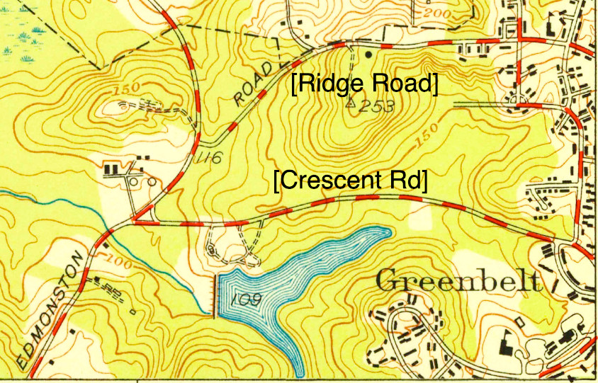
Ridge Road loops around old Greenbelt from its beginning at 1 Court to its western end where it meets Crescent Road at the police station. Its length is approximately three miles. Almost all of it was built in the 1930s and 40s when Greenbelt was built. One section, however, is much older. It is all that is left of an old road that predates Greenbelt by 200 years. That was the road to Riddle’s Bridge.
Riddle’s Bridge (and before it, Riddle’s Ford) was a well-known landmark in northern Prince George’s County in the 18th and 19th centuries. It was located near the confluence of Beck’s Branch and the main Beaver Dam Creek, approximately where the Baltimore-Washington Parkway passes over Beaver Dam Road today. From the Colonial era through the 1860s, the Riddle family owned the land around the bridge, hence the name.
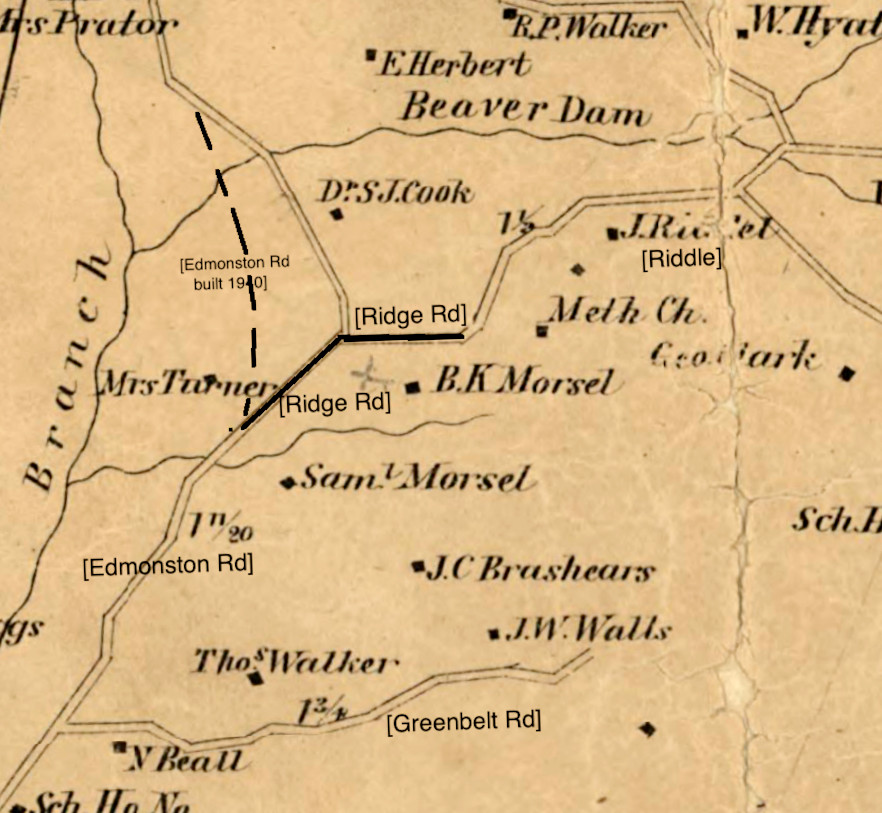
The road to Riddle’s Bridge was described in the 1739 and 1762 county road surveys. In the latter it was recorded as running “from Bladensburg by the late Captain Edmonston and so afterwards John Riddles.” Edmonston’s land encompassed much of Berwyn Heights. The southern section of that road is now known as Edmonston Road from Bladensburg to Greenbelt.
The Road’s Path
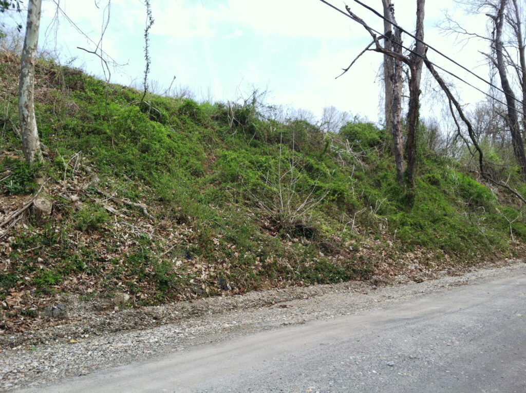
From the approximate site of Greenbelt High School (currently Dora Kennedy French Immersion) the road to Riddle’s Bridge then jutted northeasterly across the maze of 1950s and ’60s pavement of Kenilworth Avenue and the Beltway to climb 150 feet to the heights where the water tower now sits. The ancient sunken road winding up the hill (now closed to vehicular traffic) once saw yokes of oxen trudge up and down its path. Hogsheads of tobacco rolled down the road on the way to the port of Bladensburg. Tobacco planters, tenant farmers, indentured servants and enslaved men and women all traversed this road.
Even the pioneers of the New Deal city negotiated the hill with their automobiles when Greenbelt was still new. In the early 19th century, when Edmonston Road was opened northward to Beltsville, it climbed the hill on the same path before descending down the north side, avoiding the low swampy area that was only conquered by modern highway engineering in 1940 (Greenbelt Cooperator, July 18, 1940).
From the top of the hill (at the water tower), the road to Riddle’s Bridge followed the course of present-day Ridge Road as far east as Research Road. Ridge Road homes with addresses in the 100s eastward to the 70 courts front upon the old colonial road. From about Research, the road then headed northeasterly toward the bridge, passing through land owned and farmed by the Riddle family. It carried travelers into and out of the vast area of the Patuxent watershed known historically as “the Forest of Prince George’s County.”
An important milestone in the history of the road occurred on May 2, 1798, when the county’s levy court “ordered that Gabriel P. Van Horn and Richard Cramphin arrange with some party or parties to construct a bridge at Riddle’s Ford over the Eastern Branch and supervise the maintenance of the same for a period of five years” (R. Lee Van Horn in Out of the Past: Prince Georgeans and their Land). Beaver Dam Creek and Beck’s Branch at that time had not yet been so named; they were considered the upper reaches of the Eastern Branch of the Potomac River, now called the Anacostia.
Landmarks
Notable landmarks along the road to Riddle’s Bridge included the country home of Benjamin K. Morsell (1791-1870), a merchant, politician and judge in Washington. He called his home Montebello. It was located near the present-day water tower at the top of the hill. Morsell’s land encompassed most of Boxwood Village below. A native of Beltsville and veteran of the War of 1812, he kept his own farm in Greenbelt throughout his career in Washington, retiring to Montebello a few years before the Civil War.
A later owner of Montebello was Milton E. Smith. The Washington Evening Star reported on December 27, 1892, that “a very enjoyable Sunday school celebration took place on Monday at Montebello, the residence of Mr. Milton E. Smith, editor of the Church News, near Branchville.” Montebello was a center of Roman Catholic activities, including occasional masses, until Holy Redeemer Church was built in Berwyn Heights in 1912.
The Hurley family bought Montebello in 1925 and sold it to the federal government for Greenbelt in 1936. A map entitled Our Town, published in the Greenbelt Cooperator on May 9, 1940, calls the hill “Hurley Hill.” It also depicts the long cedar-lined drive that led to the house. The cedars were still standing in 1965, when the News Review reported that they could still be seen from Braden Field in the center of town (April 29, 1965).
Another site just off the road to Riddle’s Bridge was the Union Methodist Chapel. The heirs of Samuel and Susannah Turner sold an acre of land to the trustees of the Methodist Episcopal Church for the chapel in 1824. It is marked on Simon J. Martenet’s Atlas of Prince George’s County, 1861. No records have been found to document its demise, but it was gone by 1878 when the G.M. Hopkins map of the county was published.
Federal Acquisition
In the 1930s the federal government acquired the land around and beyond Riddle’s Bridge to add to the Beltsville Agricultural Research Center. The homes and farms beyond the bridge were abandoned. Soon after Greenbelt was built, that part of the old road heading northeasterly from newly named Ridge Road was closed. The road to Riddle’s Bridge soon faded from memory.