At the December 8 Greenbelt City Council meeting, Mayor Emmett Jordan opened the discussion by noting resident concerns about poor cellphone coverage in parts of the city. In response to those concerns, he announced that he would request a January 5 worksession on the topic (which was later approved by council). See our separate story about the charter amendment required for unionization of Public Works employees and other actions taken at the meeting. Both stories are on the front page of our December 18 issue.
Councilmember Jenni Pompi said, “It’s important that residents hear from council that we recognize that this is a problem and we’re dedicated to moving forward in a way that solves the problem … We’re going to empower the city manager to do everything he can to see how we can bring more providers and better service.”
Councilmember Kristin Weaver added that it’s also an issue of cellphone towers and wondered if perhaps shorter/smaller towers and other new tech devices could be considered. In one example of alternatives to tall cellphone towers, City Manager Josué Salmerón described New Carrollton’s move to allow small cellphone towers to be attached to lighting poles, which provide not only good coverage but also revenue for the city. Jordan ended the discussion by expressing his expectation of a “lively discussion” among residents and council at the worksession on January 5.
Traffic Calming Study
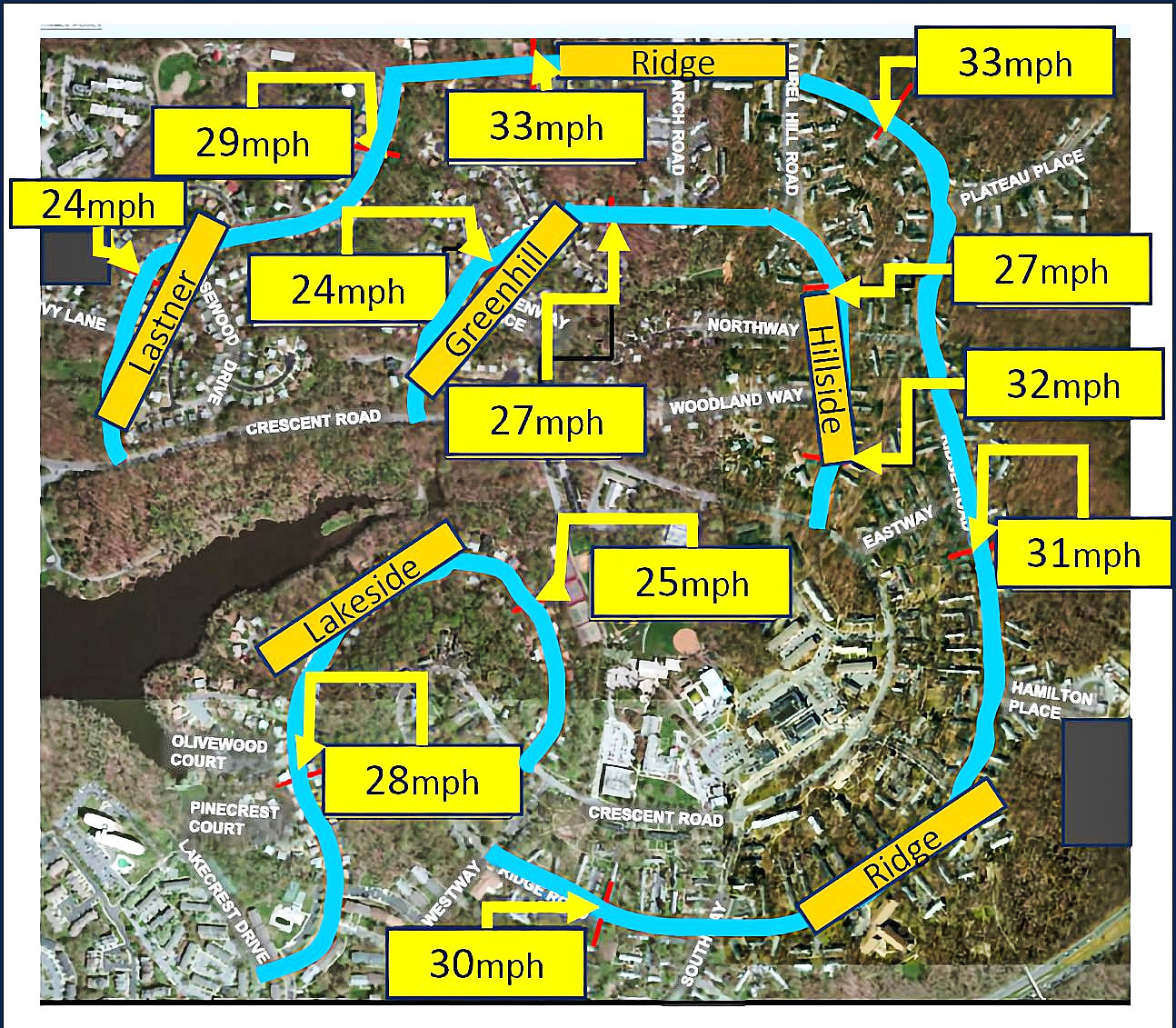
Assistant Director of Planning Jaime Fearer summarized for council and residents a recently completed 500-page report on speeding conditions and proposed measures to address them on five roadways in Greenbelt’s center city area. The roadways include Ridge Road from Lastner Lane to Westway, Lakeside Drive from Lakecrest Drive to Crescent Road, Lastner Lane from Ridge Road to Crescent Road, Greenhill Road from Crescent Road to Research Road and Hillside Road from Crescent Road to Research Road.
The study team included Fearer, Director of Planning and Community Development Terri Hruby and Greenman-Pederson, Inc., design consultants. The study began in the fall of 2023 with very detailed data collection on vehicle speeds and volumes on the five subject roadways. The team presented a draft report to Greenbelt’s Advisory Planning Board (APB) on October 16, 2024, held a community/public meeting on October 29, 2024, and presented its findings and recommendations at a council worksession on November 20, 2024. Based on comments received, the team revised its report and submitted its final report to the APB this October and to council in this meeting. A graphic adapted from the report shows some of the results (see page 1).
Calming Alternatives
The study provides an overview of design strategies and traffic calming treatments that were and were not considered and why. Design strategies among the team’s final recommendations include reductions in lane widths, rectangular rapid flashing beacons (i.e., pedestrian-activated devices at crosswalks that use bright, rapid-flashing yellow LED lights to alert drivers that someone is crossing), continental crosswalks (i.e., longitudinal stripes designating where to walk across the road), green pavement for bike lanes at intersections, corner radii and curb extensions, departure-side bus stops, midblock crosswalks, hardened centerlines and medians, pinch-points and chokers (i.e., road sections that narrow, creating bottlenecks that force traffic to slow down or stop), raised crosswalks and shared lane markings or sharrows (i.e., pavement markings indicating a travel lane shared by motorists and bicyclists).
The study suggests short- and long-term countermeasures at 22 locations to reduce vehicular speeds and potential collisions, and additional improvements to enhance pedestrian and cyclist “connectivity” (i.e., seamless, safe and accessible networks of sidewalks, paths and bike lanes that link people to destinations). Each of the 22 locations is assigned low, medium or high priority based on vehicle volumes, speeds and collisions. The short- and long-term recommendations and accompanying cost estimates are conceptual, and implementation will require additional engineering consultation.
In one of the questions from councilmembers and residents, resident Michael Hartman asked if the study has considered the various challenges facing persons with disabilities. In response, Fearer said that several ADA accessibility adjustments have been considered – for example, wider raised crosswalks that do not require a step up from the sidewalk – and more will be considered during implementation. After she concluded her presentation, council voted unanimously for a January 5 worksession.
Cathie Meetre assisted with this report.