The City of Greenbelt has engaged water engineering firm LimnoTech to develop flood mitigation strategies and a Community Flood Resiliency Plan to adapt to storms that drop large volumes of rain in a short time, overwhelm stormwater infrastructure and cause flooding and erosion. Greenbelt Environmental Coordinator Kevin Carpenter-Driscoll asked Greenbelt residents to help identify areas that experience flooding and erosion, during a community meeting on the evening of Wednesday, August 21 in city council chambers. He said the city has relevant information, but needs firsthand eyewitness reporting from across the city for a fuller picture and better plan.
Submission methods include an online survey form and emailing information (including photographs and videos) to Carpenter-Driscoll [see box, p.8]. The survey was described as useful for including detailed information. Multiple submissions are welcome. In addition to using the survey online, Greenbelters may also complete the survey at city booths on Information Day in Roosevelt Center on Saturday, August 30, during the Labor Day Festival.
Community Input Needed
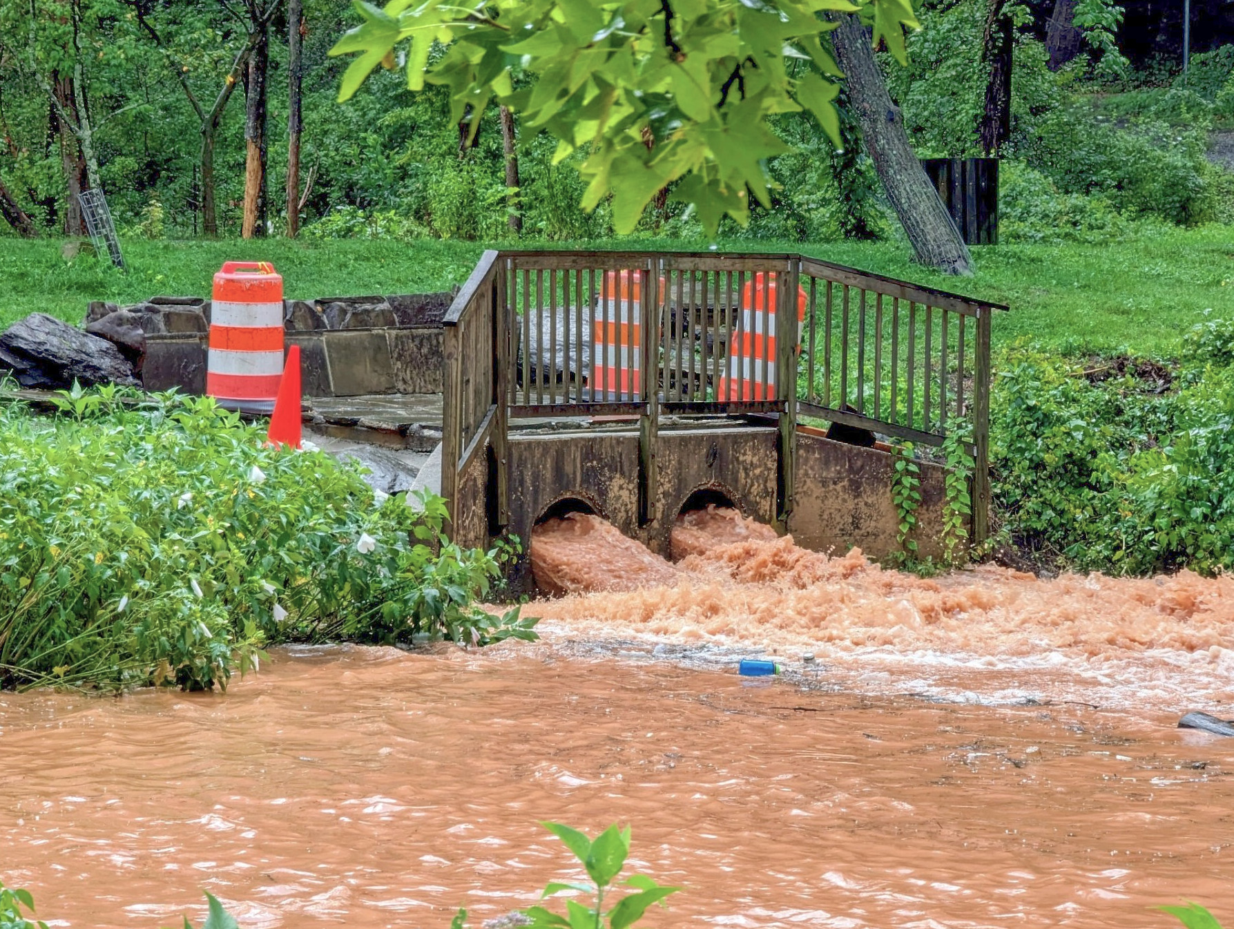
Carpenter-Driscoll said the problem is caused by storms that drop up to five inches of rain in one hour, remembering the July 19 flooding over the Lakecrest Drive forebay, Greenbelt Lake path and Braden Field, and the repeated flooding of the Parke Crescent apartments. He said Greenbelt East, Greenbelt Center and Greenbelt West all have problems specific to their hydrology, and city staff will need help in learning about everything that happens across the city during these events, so “we’re really relying on everyone to tell us where they’re experiencing problems.”
At the meeting, participants gathered around a map to place stickers on problem areas: dark, medium and light blue for major, medium and minor flooding, as well as red for erosion. LimnoTech Project Manager Anouk Savineau said they want all the information residents have about flooding and erosion, in as much detail as possible. Useful details include location, how much water was observed (for instance, to ankles or knees), how often and when (only in summer or year round) – the more specific, the better.
Savineau said documenting erosion is important since it is caused by excess water flow, and erosion impacts water quality by carrying sediment downstream where it can affect plant and aquatic life, such as in Greenbelt Lake.
The Problem of Water
Attendees described why the effort matters to them. Carolyn Lambright-Davis described water overwhelming raised beds in the Chesapeake Arts, Education and Research Society’s Springhill Lake Recreation Center garden. A resident described their Lakeside Drive home being threatened with rain flowing downhill from a GHI court. GHI Woodlands Committee member Ben Fischler discussed woodland stream bank erosion and Councilmembers Danielle McKinney and Kristen Weaver described floods near their Greenbelt Station homes. Mayor Emmett Jordan discussed three Greenbelt watersheds (Still Creek, Beaver Dam Creek and Indian Creek) and impermeable surfaces that contribute to flooding and erosion, including water rushing downhill over impermeable surfaces to lower points.
What Is Resiliency?
Carpenter-Driscoll said that in storms with large loads of rushing water, a flood-resilient community can slow the flow, contain the water and let it slowly infiltrate and move to the next part of the stormwater system, instead of causing danger and damage. He said, “It’s being more like a sponge.”
Savineau said flooding may have varied causes, including storm sewer inlets being too small or the sewers themselves being too small so water enters them without being able to quickly move on. The News Review asked Carpenter-Driscoll whether new stormwater infrastructure or practices are needed. He said those could be useful in new developments, but it’s not financially feasible to retrofit existing stormwater infrastructure.
Answering a question about what can be done differently to address stormwater threats, he said, “That’s what we’re trying to find out. We have limited funds, so where should we focus those funds to make the most impact? That’s what we want to glean from [identifying problem areas]. Once we have that, we have a roadmap to look for funding sources.”
LimnoTech will combine problem area reporting with city information, storm sewer infrastructure data from Prince George’s County and hopefully the Washington Suburban Sanitary Commission, as well as state climate change projections. They will use all this information to map and model where and how water flows and backs up in Greenbelt, organize the problem areas in a hierarchy and propose mitigation options across the city. They expect the effort to take about six months. Carpenter-Driscoll said there will be a project update in a council worksession this fall and a final presentation in early 2026.